
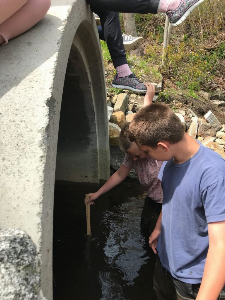
Mya and Thomas measure 26 ” of water in the culvert, an hour before a 10.3 high tide on May 16th. Making our calculations, we determined this tide would come in another 1/12th of its total height, and this would be just shy of the elevation of the outlet of the marsh. Close!
Contributed by Maggie Gill
The watershed of our marsh is in trouble, especially for the alewives.
As you might already know, the alewives that used to thrive in our town disappeared for over 30 years, leaving everyone wondering ‘What happened?’ Two years ago we got another shock; they came back! But there might be another problem on our hands now…
In science class, we have been studying the salinity in the marsh. Using the refractometers that measure the salinity in water, we took two samples from the marsh and three different points near the stream and the culvert on May 16th. We took the samples back to the classroom and measured how much salt was in the water in each sample. Fortunately, water coming directly from the marsh was found to have zero parts of salt per thousand parts of water (0 ppt). In the stream itself we found anywhere from 4-27 ppt because of the tidal influence. We do think that some tides bring salt waters right over the outlet and directly into the marsh.
Now, you may be thinking “Okay, so there’s a little bit of salt in the waters of the marsh. What’s the big deal? And how does this relate to the alewives?” Here’s the problem about the salt in our watershed; research suggests that alewife eggs develop best in less than 5 ppt of salinity. Now is where the other part of our studies comes in.
Along with studying salinity, we have been studying tides that can flood into the marsh. According to the ‘rule of twelfths” of a tide cycle, we can go down to the marsh at any time and find out if the coming (or leaving) tide will (or has) flood (or flooded) the marsh. Here’s an example of how to calculate the final height of the tide; Say it was 1 hour before the coming 8.7 foot high tide. First, we would measure the water in the culvert, and let’s say that that we measured 10 inches in the culvert. Then we go back to the classroom and start calculating, knowing the time we made the observation, the time of the high tide, and the predicted depth of the tide. First, we find 1/12 of the 8.7 foot tide since there is another hour of water to come in on the tide. One-twelfth of 8.7 feet is 0.73 feet. Then we find out how many inches 0.73 feet is. That answer is 8 and 1/2 inches. The next step is to add this to our original measurement of 10 inches for a total of 18 and 1/2 inches. Since the difference in elevation between the bottom of the culvert and the outlet of the marsh is approximately three feet, this high tide of 8.7 feet, with 18 – 1/2 inches of water in the culvert would not flood the culvert.
In conclusion, the marsh’s alewives run may be in even more trouble, even if you can’t see the damage as its happening. To keep you updated, you could check out our website, https://marshwatershed.edublogs.org/ .
Note: Thanks to a grant from the Gulf of Maine Research Institute’s “Vital Signs” Freshwater Investigations program, and direction from Paul Meinersmann, students are building a digital salinity sensor station to deploy in the marsh. Students are reading and learning about how the different parts work, how they connect together, how to write code in order to give the sensor commands. After testing, it will be ready to go. Collecting salinity data over time will give us a better view of how tides influence the freshwater of the marsh and possibly the alewives.
