
Monthly Archives: April 2017
Adrien’s Track
Contributed by Adrien Williams
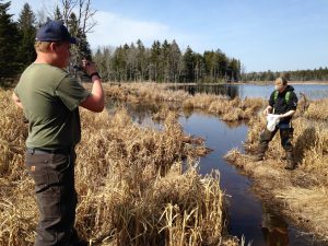
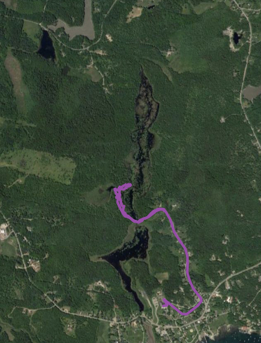
I asked Mrs. England if we could go for a walk in the woods and go up in the upper Marsh. I wanted to get outside and we both decided to see if we could walk across the beaver dam and follow the edge of the water and see where the road was flooded. The “road” isn’t usually flooded and our class is planning to walk through the road along the upper Marsh from Watts Avenue to Ponderosa. Mrs. England invited Eli Miller to come along because he made wood duck nesting boxes that are up there and he knows lots about the ground up there. We started out after school was over, Tuesday, April 11th.
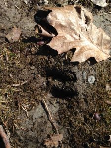
We started in from Watts Ave and I recorded a track on the GPS unit I was carrying so we could see exactly where we went and where the flooding was. Before we even got to the woods, we saw deer tracks. The water was going around the end of the beaver dam. There’s a lot of water coming through. I think if the dam ever went out it would flood the main road down by the culvert.

There’s a lot of water coming through. I think if the dam ever went out it would flood the main road down by the culvert.
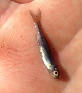
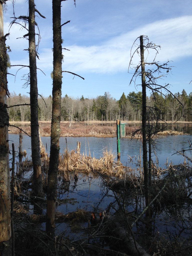
When we followed the trail we didn’t go far before it was under water. I saw about ten minnows in the flooded wheel ruts. I tried catching them with the net and got one. We are wondering what kind of species it is. We were seeing geese and ducks flying around back here, more than in the Marsh itself. In the distance we could see a wood duck box.
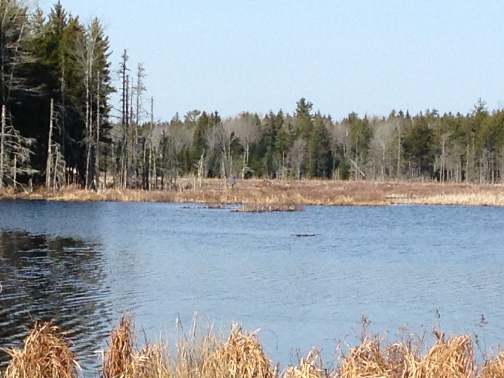
We went around the wet spot through a field and when we stepped back in the woods we found a giant ant hill. Then we went through a thicket, then it opened up again and there was another beaver dam. We checked out a flooded area behind this beaver dam and some ducks flew off the water. I was first to walk across the beaver dam where if you fell over you might go in about four feet of water. Then Mrs. England came across.
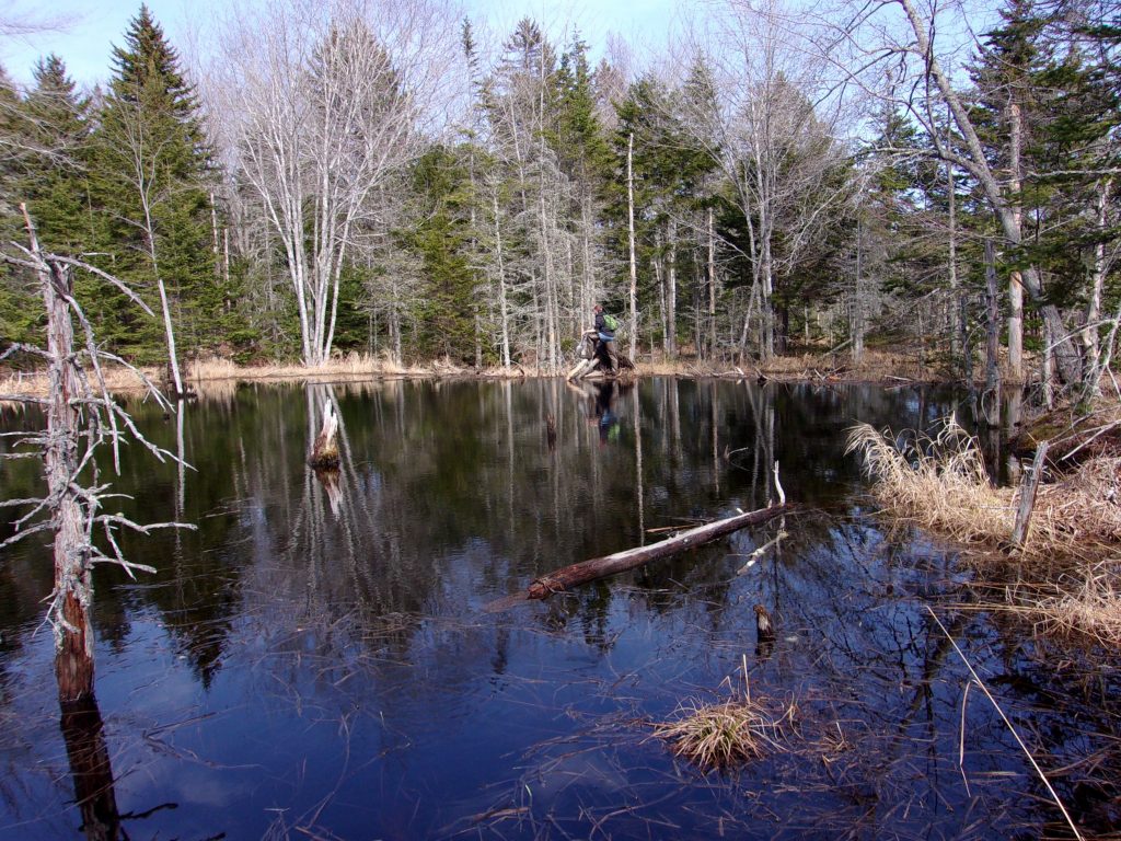
We crossed the trail and into the woods to see the duck box. I noticed there were two bones under a log Mrs. England had walked over. I think they may go to a duck, because they are similar to the gull skeleton in the science room, but not the same. There were all kinds of geese along the edges and we stood quietly so they didn’t fly away. Along this edge, Eli told us the channel could be ten feet deep. There was a LOT more marsh up there. So far, it was like seeing two whole regular Marshes, or more than ten football fields. Then we had to head back to school because we had run out of time. We both want to go back and canoe the whole upper part.
I liked that I got to walk in the woods and how big the upper Marsh was. I was surprised there were so many ducks and geese up there. I can’t wait to go back.
Groundwater Contamination in Tenants Harbor Village (1997)
Town Manager Tim Polky came to class to tell us about a home oil fuel leak that led to the Tenants Harbor Water District.

In 1997, a home heating oil company employee doing some maintenance on a home owner’s furnace at 6 Watts Avenue accidentally stepped on the copper tubing of the oil tank in the basement. Oil leaked out into the cellar. A sump pump emptied the oil and water that had collected and pumped it right next to the homeowner’s well, contaminating the well water.
The state helped assess how many people’s wells may have been affected. Testing of wells and groundwater began. They found petroleum in people’s wells and had to keep testing wells to find some that were not contaminated, to know how big an area was affected. They found oil products in some wells that didn’t come from the Watts Avenue leak. Unfortunately, it was common practice for garages and even homeowners to dispose of oil by pouring it down into the ground. Most people had a dump in their yards. There was a garage that used to be where Harbor Builders have their offices now. Another garage was where the parking lot of the Marsh is now. Back then, waste oil could also be used on driveways to control dust. With all the testing, the officials knew there were multiple sources of oil pollution in people’s wells. People needed a clean water supply.
Land was bought on the Wallston Road with state and federal money. The funding also helped pay for the well equipment and to help operate the wells for the first ten years. Now there are two town wells near the Transfer Station that are around 600 feet deep and have enough flow to serve 600 people. Today, those two town wells are connected to about 350 people’s houses and our school, to provide clean water. Until the water district wells were up and running, people
had filters on their home wells to clean the water before it was used. Any residents on town water have to pay a monthly bill for the water they use.

The boundary of the water district was formed using the topography of the land (the natural ridges). The water district stretches from the north end of Watts Avenue, east to Spruce Lane on Barter’s Point Rd, south to the Sea Store and west as far as the Transfer Station. Groundwater from around the Transfer Station gets tested from time to time to make sure that the old dump is not a source of pollution today.
A big thanks to Mr. Polky for taking the time to visit our class and talk to us about this town history. We never knew about this oil spill until he taught us about it. We should be careful with oils, gasoline and other products, like paints and chemicals that could get into our water so nothing like this happens in the future and we continue to have clean water to drink.
The Movement of Water in a Watershed
Authored by Lute, Henry, Gwen, Addie, Lydia, Ella, Leah, Taylor, James, Mya
In class we have been learning about watersheds and their features and processes. We were hoping to learn what a watershed was and what nature does almost every single day! We learned a watershed is a place in the land where all the water flows to one big river, lake or pond. We have also been learning about point source pollution and non-point source of pollution and how pollution can spread to other features of our watershed.


We got cans, crumpled them up, taped them together, and put tin foil over it. We then squirted water all over it. When we squirted the water which we colored with blue food dye, the indents filled up, creating a water body. The water in the lake came from the mountain when it rained. Sometimes, water trickled downhill, creating a stream or river. One model showed three lakes, seven major ponds, three wetlands and many smaller water features throughout, one waterfall and a river. In another model, as soon as it rained, the water would run down a small ledge and into our lake. It was not really a stream or river though. The water only ran down the ledge when it rained, whereas other rivers and streams on our watershed held water even when it wasn’t raining. If there were any holes in the tin foil the water that ran over that spot went under the tinfoil and cans and became groundwater. Groundwater is surface water that has soaked into the ground. When we stopped quirting the blue water, the run-off stopped.


We then put three pieces of fabric onto three random spots. The fabric symbolized wetlands. Our point source of pollution was a drop of red food dye on the cloth that represented the wetland. We made it rain again. The dye would be a point source of pollution because you could point to it. The point source of pollution spread almost all the way across one group’s watershed, and ended up in a small lake. In another group, the red dye flowed into small streams and rivers and then collected in lakes and ponds. Most of the pollution stayed there, but some overflowed and became groundwater. A different group explained the pollution affected the watershed because it got spread out when it rained. The point source of pollution ended up in their lake and in their mini-pond. In another model the red food dye ran into streams and into lakes and ponds and into the ground.
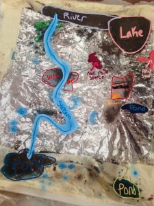

We added dirt after that. The dirt was a non-point source of pollution. Then we made it rain again. The dirt mostly flowed through rivers and into the lakes we had. A tiny bit of dirt was left over that didn’t flow away with the rivers. One group placed the soil around the stream, finding out the dirt followed the stream and ran into the groundwater. The non-point pollution affected our watershed and when you looked at the lakes and ponds you couldn’t say where the pollution was coming from.
Here is more of what we had to say after using our models:
This model helped me learn the connections between surface water and groundwater because whatever kind of water is on the surface eventually goes to the ground.
This taught me there is a big connection between surface water and groundwater. This connection is that what goes on at the surface will end up in the ground at some point.
This model taught me about the connections between surface waters and groundwater because all the water on the top of the watershed will soon be down in the ground.
This model taught me about the connections of surface water and groundwater. I learned that the water on the surface will eventually end up in the groundwater. A negative fact about this though, is that if pollution is in the surface water, and it eventually goes into the ground, that pollution will travel and can hurt things that are under the ground. This also happened to our model. Some of the pollution went into our groundwater, but also went into our lakes and small ponds or puddles.
This project really helped me understand how pollution travels, and helped me learn about watersheds.
Getting Outdoors to the Marsh!
Finally, the weather turned warm and we took at walk on the Nature Trail to the Marsh. We listened for birds and started a list of species of wildlife we saw or heard. We wanted to stay outdoors all day long!
Topography and the Watershed
Our class has been learning about topographic maps. Learning about topographic maps will help us learn about the watershed of the marsh. We are learning how the surrounding land of the marsh has the potential to affect the water quality of the marsh.

A topo map shows the elevation and the lay of the land. With a regular map, it only shows the streams, rivers, etc, but the topo map allows you to see which way the streams and rivers are flowing. Another thing that makes a topo map different is the contour lines. These lines tell you how steep or level the area is. The closer the contour lines are, the steeper the terrain. The farther apart they are, the more level the terrain.
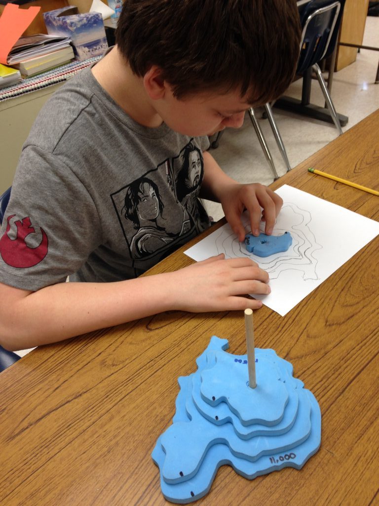
We used 3-D models of a land form to make our own topo maps. Our topo map displayed the elevations and we added our own imaginary hiking trails. These trails could be on a steep, more challenging path or a more gradual or level path. Next we made a side or profile view. This gave us a different way to interpret the contour lines of our landform on the topo map.
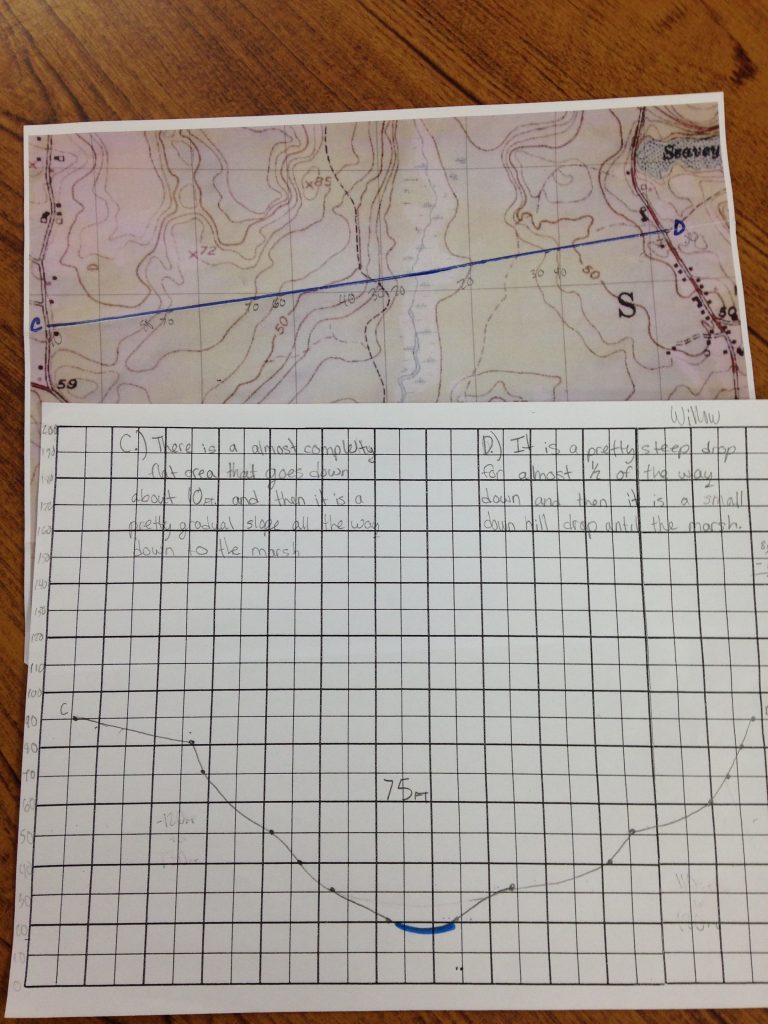
Learning about topography of the land around the Marsh let us understand the definition of a watershed because we could tell from the contour lines that the land sloped downhill to the Marsh. A watershed is an area of land that drains into a single river or body of water. Our watershed is nearly three square miles! We are excited to explore the next step in our watershed project.
Contributed by Willow McConnochie