History through the Eyes of Students

Contributed by Leilani Myers, Anna Hooper, Madisyn Morris, Hayzel Poland, Isla Mitchell, Ella Cushman and Brooke Hoppe.

Following John Falla’s classroom visit, students did some writing about the images and information he shared that helped us understand how the stream became a marsh.  

View of the marsh, circa 1930’s – 1940’s

Leilani Myers writes:  “This picture was taken in the between the 1930’s and 1940’s. It was taken over the bank on the marsh, where there are now scrubby little bushes. It shows the marsh, the field where the library now stands, and the tip of the point on the marsh trail. The pine trees on the far right and in the background on the edge of the field are no longer here.

It makes me want to learn more about how the landscape has changed over the years and what caused it to change. Mr. Falla talked about the changing water levels. The photo seems to have more water and the point of the trail is a lot smaller than it does now. The water level would affect the alewives that live and come to spawn in the marsh, and if it gets too low, they won’t be able to travel to and from  the marsh anymore, which would mean no more baby alewives, and in the long run, no more ALEWIVES!!!

I like all the trees in the photo, and that there are no buildings or signs of civilization anywhere. I would like to print this photo out and go down to the marsh, to compare it to the marsh now.

Thank you Mr.Falla, for teaching us about the Marsh and its history!”

Ice cutting in the 1940’s

Anna Hooper writes:  “I chose this image because it seems interesting and I want to learn more about it. In the image they are cutting the ice for the icehouse. They also use the ice for shipping the fish away. This image was taken in the 1940’s at the marsh and it looks a lot different than now. They were able to cut the ice in the 1940’s because the water level was higher than it is now. In another picture we saw the ice house near the marsh.

Knowing that the level of the water is lower and the tide can come in makes us wonder if this is why there are fewer alewives.   Thank you Mr. Falla for coming in and talking about the marsh and what your experience. Now I would like to know more about the marsh.”  

Madisyn Morris writes:  “I think this image looks interesting.  The reason I think the picture is interesting is because people don’t do this anymore….The ice was also very important because people had ice boxes before refrigerators.  Everyone in the town needed the ice to keep their food stored safely.  The Davis brothers probably made money too.”


Artist rendering of the Marsh and the Davis Bros. Ice House, circa 1900 – 1910

Hayzel Poland writes:  “This is a painting of the marsh that was made in the 1900’s.  When it was the 1900’s the marsh had an “icehouse” that is in the top right corner of this painting.  A family business named the Davis Brothers used to take chunks of ice and put it in the icehouse.  The Davis Brothers had an ice business, but in order to do that they had to get permission from all the local landowners whose property was near the marsh that would overflow, so they could make a dam in the marsh at the outlet…It is surprising how much has changed from then and now.  There were different water levels, and there is no more icehouse, but the rock that is seen in this painting is still here to this very day.”

Isla Mitchell adds, “The thing I like about the photo is it reminds me of the ice pond on Monhegan Island.”

Ella Cushman also notes:  “The icehouse in the picture is where the library in Tenants Harbor is right now, so when you start to think about that, it was around 100 years ago…Twenty-five years after this picture both of my great grandmas were born, and I was born in 2006.  I wonder what it will be like 100 years from now.”

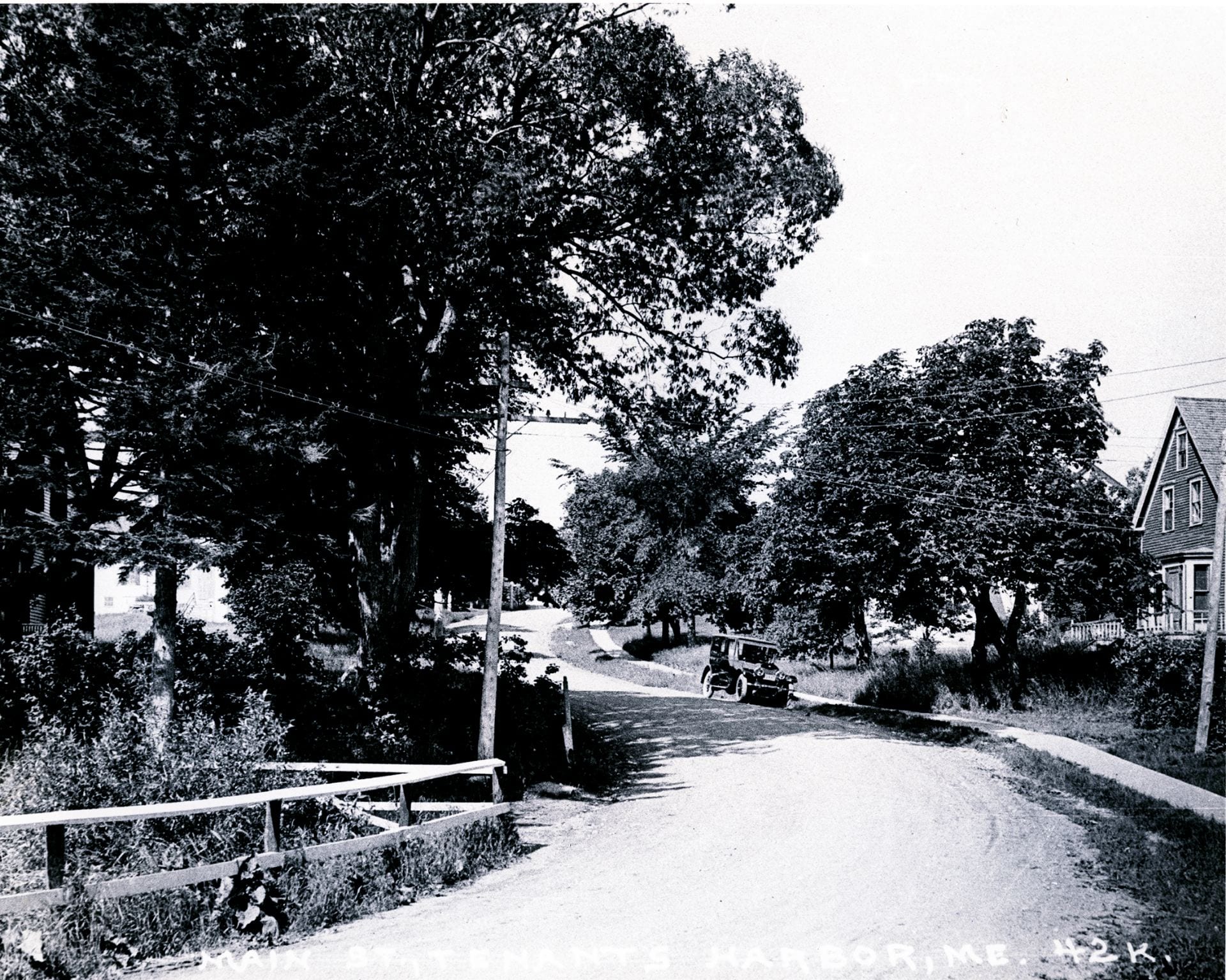
Main St. in Tenants Harbor, 1910

Brooke Hoppe writes:  “This is a picture that was taken in 1910 of the road alongside the stream from the marsh. Today, this is still the exact same spot where the culvert is.  The house to the right of the picture is still there too.  Some differences from the picture and what it looks like today are the road and the sidewalks.  In the picture, the road looks like a dirt road, but currently, the road is paved.  The sidewalks in the picture are wooden planks, but now the sidewalks are concrete.  Also, the big trees in front of the house to the right aren’t there anymore.

What comes to my mind when I look at this picture is how it still looks very similar to today.  I think it’s cool how the car is in this photo because it gives you a better idea of how long ago it was.  This picture was taken over 100 years ago.  Just imagine what it’s going to look like one hundred years from today!

Thank you to Mr. Falla for coming into our classroom and telling us about some history of St. George and the marsh.”

Main St. Tenants Harbor, 2019

Our “Now and Then” images!

View from the back of the parking area, 2019

This photo is all about the rocks! These rocks on the lower right are the only sign of what remains the same from the photo that follows! The two houses were removed in the 1960’s.

All that remains from the house on the left is the foundation pillar in the stream today. Both houses were torn down in the 1960’s. Their site is today’s parking area for marsh access.

In 2019 we are re-creating the shot of the ice cutting activity of the 1940’s image (see above)!

Mysteries, History and a Story of Dams!

Good mysteries sometimes start when history gets lost.  Mr. Falla, who may know our community better than anyone else, helped us gain a better understanding of our natural history when he visited our class to share a part of the story of “the marsh” in Tenants Harbor.

Town Map, 1857

Our question began when we noticed the 1857 map of Tenants Harbor (in the basement of the Town Office) showing a meandering stream where the marsh is today.  WHERE IS OUR MARSH?  The box encloses the area from today’s Route 131 to the south and the Watt’s Avenue trail crossing to the north.

We invited John Falla to our classroom in early December to help us try and understand how a stream became a marsh.  He brought many images and shared the following:

George York and his heirs owned the 168 acres of land “beginning at a stake and stones by a spruce stump at Tennents harbour a little to the sourthward of the Outlet of Marsh Creek (so called)…to a spruce Tree…” according to the deed given by Henry and Lucy Knox in 1788.  Town records for Cushing (which included the town of St. George from 1789 to 1803) also mention that notices for official town meetings must be posted at several locations – one of the locations being the mill of John York; likely the same heir of George mentioned in the the 1788 deed from Henry Knox.  Did John York have a small dam to harness the water of the stream?  Was it a tidal mill?.


The Smalley Map and the York property

1795 Deed to York Heirs, as recorded in County record


By 1857, when the map of the town shows a stream, Mr. Falla discovered that deeds to property in this area refer to it as the Marsh Brook or Marsh Creek.  Then, in 1890, the story continues with the Davis Brothers who went into business producing ice.  On June 5th, 1890, a deed shows a ten year agreement between the land owners and the Davis Brothers “granting…the privilege… to raise the water on said Marsh about five feet by building a dam across Marsh Creek near Ripley’s bridge for their purpose of cutting and taking ice from said Marsh Creek.”  The ice business, and the ice house, may have lasted until around 1910.

Lease Agreement with the Davis Brothers, 1890

The Davis Brothers Ice House as depicted in a turn of the century art image. Today, from this vantage we would see the Jackson Memorial Library just behind the icehouse. The rock in the foreground is visible today. Walk down the bank at the back of the parking area and look to the left.

Fast forward to the 1950’s.  Mr. Falla told us, “I was born in 1954 and lived in the area next to the Marsh up to three years ago.   As a kid and into my teens I remember the alewives running each year.  The status of the dam at the Marsh was that it was built up a lot higher than it is now – at least three to four feet higher.  There was a board dam on the easterly side of the dam.  What I mean by a board dam is that there were concrete sides and you could slide thick boards into place in order to raise the water level.  I remember this was the area that water poured out of the Marsh and the same place that the alewives would jump up into the Marsh. A couple of things that have changed since my younger days is that the dam, and therefore the water level, is a lot lower than it used to be.”

So when did the stream or creek become our marsh?  Likely, “the marsh” we are used to seeing today was created over time, beginning in the late1800’s as people manipulated the stream to harvest ice.  What was a naturally occurring stream with relatively flat elevations surrounding the area, eventually became a flooded wetland that allowed a different use of this natural resource.

For a time after the man-made dam at the outlet no longer existed, the beaver that inhabited the marsh at the time kept the water levels up.  The beaver dam washed out in the spring of 1994 or 1995, according to John Falla and his daughter Becky.  They remember because that year they took a family trip to Florida and came back to find big changes from the storm. Since then, the water level of the marsh has been significantly lower.

So we’ve shed light on our mystery…historical documents and a knowledgeable historian re-have awakened the story of our marsh so we may know the rich community connections we have with this natural resources.  Its story continues!


All the images in this post (with the exceptions below) came from images John Falla shared in class and made available to us.  Thank you! John Falla for your research and willingness to share your resources, knowledge and passion for history with us!

NOTES:

We also know from Jeff Falla and Robert Morris, who visited our classroom in the spring of 2016, that when Robert and Jeff were younger, they would catch the alewives for fun with a colander and then they would flip them over the beaver dam into the marsh to help them get there. They mentioned that there was never a big run, but a couple lobstermen from Wheeler Bay did come to catch some alewives for lobster bait when the fish ran in the spring. They added how they remembered sewage from houses had run from the backyards of those houses and down into the marsh. After swimming in the creek they would come out with red blotches all over their body. When the house that used to be on the granite piling over the stream flushed the toilet, it would go right into the creek. Back then, there were bottom feeding fish, like flounder, that would come all the way up the creek as far as the culvert. They explained that they believed the fish would feed off the solid waste. They used to see mackerel in the creek too.

Jeff remembered a dam that used to be on the ocean side of Route 131.  He drew us a picture of it a few days later. (Interview notes, 2016)


This is a drawing made by Jeff Falla after he visited our class. His notes remark that it was a cement wall, a foot thick and two and a half to three feet high and twenty-five to thirty feet long.


Just this month, (January, 2018) John Falla discovered aerial images on the James Sewall Company’s website that showed the structure on Ripley Creek, though very fuzzy.  We contacted the company and they generously granted us access to higher resolution images from 1957 and 1963.

Small area closeup, Sewall Company Historical Archives

Here is a small area of the December 1963 image that clearly shows the structure on the ocean side!  We were very excited to see this documentation and are indebted to the Sewall Company for making it available to us and enthusiastically supporting our school and community project.